I will be observing Australia's weather in a 3-day period. It will be from March 19-21. The forecasted high for my first day is 72ºF and the forecasted low is 47ºF. The precipitation percentage on this day is 0%. The forecasted high for my second day is 70ºF and the forecasted low is 48ºF. The precipitation percentage on this day is 0%. the forecasted high for my third day is 74ºF and the forecasted low is 48ºF. The precipitation percentage is 10%. The average pressure during the three way period was 30.05. The pressure increased over the three day period. The average wind speed over the five day period was 7 MPH.
The above diagram shows Canberra's radar. Since Australia is a desert, there are barely any clouds as you can see. Although there are clouds above the mountains, they are cold clouds. There is no precipitation whatsoever in the city of Canberra. It looks like they are having clear skies today. It should be great weather to go out and have fun. There are however clouds on the mountains that are green, which shows that there will be light to no rain over the mountains. The type of surface is pretty much a city and a few mountains, or land desert. There is a lake west of the mountain.
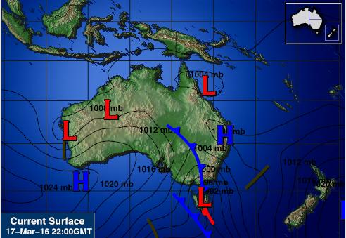
The area of Canberra is shown above. They are currently experiencing a cold front that is headed and located East of the country. It is a low pressure area, about 1000mb. Pressure decreases as you move South. Also to the south of Australia, there is a warm front. That location has a very low pressure.
Above photo shows the entire Australia. North of Australia is covered with low pressure system while south has both high and low pressures. Average pressure is about 1012mb. A cold front is located East of the country and will also be heading East. Highest pressure is located in the Southwest with 1024mb and low pressure system is in the Southeast with about 892mb.


No comments:
Post a Comment