Thursday, April 28, 2016

Climate Change Impacts in Australia

Any part of the world will have specific climate impacts. In Australia, the specific climate impacts are mostly biological systems. Though however located West of Australia, it is affected by physical systems. A little Northwest of Australia, it is affected by human and managed system. Northwest of Australia seems to have the most human and physical impacts. There are factories located in that area. The rest of Australia is just wildlife. The risks associated with these impacts in Australia include change in community composition and structure of coral reef systems in Australia, increased frequency and intensity of flood damage to infrastructure and settlements in Australia and New Zealand, and increased risk to coastal infrastructure.

The climate of Australia is a mix of tropical and extratropical influences. Eastern-northeastern Australian rainfall is strongly influenced by the ENSO cycles, with La Nina years typically associated with wet conditions and more frequent and intense tropical cyclones in summer and El Nino years with drier than normal conditions, most notably in spring. Over southeastern Australia, the decreasing rainfall trend is the largest in autumn with sustained declines during the drought. A recent analysis shows that climate projections over Australia using CMIP5 models which generally simulate the climate of of Australia well, are highly consistent (Fyfe 1273, 1274, 1275). 

In Australia, the regional climate is changing very quickly. The region continues to demonstrate long-term trends towards higher surface air and sea surface temperatures. There will be more extreme cold and extreme hot. In the last 50 years, increasing greenhouse gases have contributed to rising average temperatures in Australia. This warming is continued to increase throughout the years. The warming is expected to be associated with rising snow lines. Annual average rainfall is expected to decrease in southwestern Australia. There is an uncertainty in projected rainfall changes, which creates significant challenges for adaptation. These scenarios would have severe implication for agriculture, rural livelihoods, ecosystems, and urban water supply, and would increase the need for transformational adaptation. Without these adaptations, further changes in climate, atmospheric CO2 and ocean acidity are projected to have substantial impacts on water resources. While adaptation is already happening, it is becoming embedded in some planning processes, albeit mostly at the conceptual rather than implementation level. 

Australia exhibits a wide diversity of climates, such as moist tropical monsoonal, arid, and moist temperature, including alpine conditions. There is high confidence that climate change is already affecting the oceans around Australia and warming the Tasman sea in the northern New Zealand. The marine ecosystems of both countries are considered hotspots of global marine biodiversity with many rare, endemic, and commercially important species. I chose this issue because marine ecosystem and wildlife play an important role in Australia's tourism. If this gets affected, it will cause a chain reaction to the country's economy. It will affect tourism if something happens to their wildlife, which will affect their economy. 

The figure above shows the locations in Australia that are vulnerable. 

Friday, April 15, 2016

Severe Weather in Australia

If you do not already know what tornadoes are, tornadoes are basically wind. It is a rapidly rotating narrow region of low pressure. Its wind speeds can range from 70-300 mph. When a tornado first starts, it begins with rotating body of air on the ground. This happens because of vertical wind shear. The horizontal rotating air is then lifted off the ground by updraft of a thunderstorm. Once it is rotated nearly vertically, it is considered a mesocyclone. The mesocyclone is then fully developed in the updraft of a thunderstorm. 

In the United States, tornadoes are most common towards the center east of the country. Tornadoes in the US travel from southwest to northeast or west to east. This is because of an increased frequency of certain tornado-producing weather patterns (hurricanes in south Texas, or northwest flow weather system in the upper midwest).

Tornadoes in Australia are very rare with only 10-20 tornadoes being observed annually but also has the chance to form with almost any severe thunderstorm. Some areas though however, are more prone to tornadoes than other places. 

Tornado counts in America average to about over 1000 tornadoes per year. American has the highest amount of tornadoes annually than any other country in the world. 


While tornadoes are rare in Australia, the country has not yet developed a map or statistic showing the history of tornadoes and their common occurrence. 

Within the past 30 years, the amount of tornadoes have increased significantly. The cause of this is probably because of the continued change 

Hurricanes can form anywhere. But the location of where hurricanes form must have these 3 key ingredients. The ingredients are warm ocean temperature that is deep, presence of coriolis force, and low values of vertical wind sheer. The city of Sydney, Australia rarely ever experiences hurricanes. This is because the southern hemisphere does not experience hurricanes very often. Climate is very calm. However, cyclones are common in the tropical and sub-tropical waters of Australia. 

Hurricane formation regions occur mostly near the equator and head from East to West. Cyclones happen below the equator while hurricanes happen above the equator. It happens near the Tropic of Cancer and Capricorn. 
In the United States, hurricanes move in the direction from east, the moves slightly in the northwest direction. Majority of hurricanes hit the East Coast of the United States but rarely on the West Coast. This is because of the hurricane formation region. 

Hurricanes rarely every happen in Australia. Especially Sydney, hurricanes are so rare the count is about 1 or 2 hurricanes every other passing year. 

There is an average of about 10 tropical storm that form and hit the United States annually. 

Thursday, March 17, 2016

Daily Weather in Caberra

I will be observing Australia's weather in a 3-day period. It will be from March 19-21. The forecasted high for my first day is 72ºF and the forecasted low is 47ºF. The precipitation percentage on this day is 0%. The forecasted high for my second day is 70ºF and the forecasted low is 48ºF. The precipitation percentage on this day is 0%. the forecasted high for my third day is 74ºF and the forecasted low is 48ºF. The precipitation percentage is 10%. The average pressure during the three way period was 30.05. The pressure increased over the three day period. The average wind speed over the five day period was 7 MPH.

The above diagram shows Canberra's radar. Since Australia is a desert, there are barely any clouds as you can see. Although there are clouds above the mountains, they are cold clouds. There is no precipitation whatsoever in the city of Canberra. It looks like they are having clear skies today. It should be great weather to go out and have fun. There are however clouds on the mountains that are green, which shows that there will be light to no rain over the mountains. The type of surface is pretty much a city and a few mountains, or land desert. There is a lake west of the mountain.

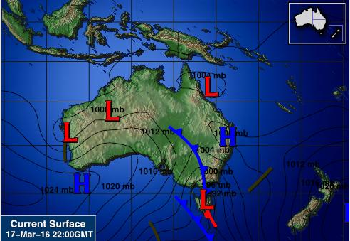
The area of Canberra is shown above. They are currently experiencing a cold front that is headed and located East of the country. It is a low pressure area, about 1000mb. Pressure decreases as you move South. Also to the south of Australia, there is a warm front. That location has a very low pressure.

Above photo shows the entire Australia. North of Australia is covered with low pressure system while south has both high and low pressures. Average pressure is about 1012mb. A cold front is located East of the country and will also be heading East. Highest pressure is located in the Southwest with 1024mb and low pressure system is in the Southeast with about 892mb.

Thursday, March 10, 2016

Global and Local Winds in Australia

The winds in Australia is very similar to the winds found in the state of Hawaii. The latitude and longitude of 35.3080ºS, 149.1245ºE. Unlike the United States, Australia is located in the Southern Hemisphere. Being in the Southern Hemisphere, the seasons are opposite lol. Australia is located in the Hadley Cell. Australia being in the Souther Hemisphere, its planetary wind belt is is the Mid-Latitude Westerlies. The wind in Australia blows from West to East, just like the rest of the world. No place on the East coast of Australia have prevailing wind, as they change with pressure systems. Australia is dominate by a belt of the high pressure system around the earth. Australia is not located near any special location. Though it is in the subtropical highs.

Australia is the driest continent on Earth. The geological features that influence the climate of Australia most strongly is the absence of sufficiently high mountain ranges west of the Great Dividing Range running north-south near the coast of the continent. Australia is dominated by the belt of high pressure around the Earth, composed of series of high pressure systems that move from west to east near the latitude of 30ºS. In summer, these high pressure systems cover the southern parts of the continent and by winter, they have moved north to the central regions. For this being, Australia experiences mostly clear skies, the descending air being dry. Westerly winds is located immediately to the south of the high pressure zone. Fronts and depressions in this band of westerly winds are areas where the air pressures are locally lower. The southeast trade winds occur immediately to the north of the high pressure belt. These winds converge with the northeast trades of the Northern Hemisphere to form the inter-tropical convergence zone, a belt where the rising warm air containing large amounts of moisture. During the summer, there is a low pressure that remains continuously over northern Australia, the monsoon season that is hot and wet.

The absence of mountains in Australia causes the winds to blow the country's moisture away. The five types of breezes associated with mountains are country breeze, desert winds, chinook winds, katabatic winds and Santa Ana winds. The wind or breeze that Australia experiences most is the country winds. This is due to the lack of mountains. Also happens but very rarely is the desert winds. This is because there are many deserts in Australia but rarely create haboobs. There are 8 coastlines in Australia. The two breezes that are associated with coastlines are sea breeze and land breeze. Australia experiences sea breezes on the East side of the country.

Thursday, February 25, 2016

Typical Weather and Tourism in Australia

Australia is located in the Southern Hemisphere. Being located in the Southern Hemisphere, winter is when summer happens in the Northern Hemisphere and vice versa. The winter solstice occurs on June 21st. Meaning this is the shortest day of the entire year. The average high during this month is 18ºC. The minimum temperature during this month is 14ºC. The type of precipitation you would likely see during the winter solstice would be rain. As June is rainy season in Australia.

In Australia, the summer solstice will occur sometime in December. Again, Australia is located on the Southern Hemisphere so the seasons are switched from the Northern Hemisphere. The exact date for the summer solstice is December 21st. The average maximum during this month is 26ºC. The average minimum temperature during this month is 16ºC. The type of precipitation that we would most likely see during this solstice is nothing really. It would just be really humid during this season.

Unlike in the Northern Hemisphere where the Spring equinox occurs in March, the Southern Hemisphere observes the Spring equinox in September. It happens on September 22nd. The average maximum temperature during this month in Australia is 20ºC. The average minimum temperature during this month is 12ºC. The type of precipitation that is most likely to happen during the equinox is nothing really. There is little to no rain at all. Snow is also absent during this time.

The Autumnal equinox in the Southern Hemisphere is observed during the month of March. It occurs on the 20th day in March. The average maximum temperature during this month is 25ºC. The average minimum temperature during this month is 18ºC. The type of precipitation that would most likely occur during the equinox is nothing. There is lots of sunshine during this season. This is usually the best time to visit the country as the weather makes for great outdoor adventures.

Australia is a very beautiful place to be in. Tourism is what makes majority of their economy. If you want to go visit Australia and get the most bang for your buck, you should visit the country during the month of March. Like I stated in my last paragraph, March is when the autumnal equinox occurs. The temperatures are of the highest during the year and makes for lots of outdoor activities, hotel chilling, and lots of other activities. Some of the activities you could do during this time is you could visit theme parks. This would make a great activity as there is little to no rainfall during this time. Another activity best during this time is go to a scenic cruise. This makes it a great activity because the weather is not too warm or too cold.

Some of the weather hazards you might see during this time of the year is the occurrence of brush fires. This is because this is the warmest and also the driest time of the year. Humidity levels are not very high. Also, a heatwave is likely to happen. But it isn't that high of a risk. The weather during this time in Australia is very similar to the weather in Hawaii, warm.

There's just nothing like Australia.

Socrata

Thursday, February 18, 2016

Temperature Controls in the city of Canberra in Australia

In this blog post, I will be talking about the temperature controls in Canberra, Australia. The capital city of Australia is Canberra. The latitude and longitude of Australia is 35.3075º S, 149.1244º E. The warmest months in Canberra are January and February with an average monthly temperature of 21ºC (70ºF). The coldest month in Canberra would be the summer months which is July with an average monthly temperature of 6ºC (43ºF). Based on the information above, the annual range of temperature for my city is 13.5ºC (56ºF). Holiday Weather.

Canberra is located on the Southeast side of the country. One of the air temperature controls that affect the city of Canberra is the geographic location. Because Australia is a small continent that is separated from polar regions by the southern ocean, it is governed by the hot, sinking air of the subtropical high pressure belt. This high pressure is located on the Southeast of the country and is very very close to Canberra, the capital of Australia. This high pressure makes things a lot more mild than what it would actually be based on the location. This high pressure makes winter temperatures fairly mild. Temperatures in Canberra never goes below freezing, again, thanks to it's high pressure system. Also, another temperature control that keeps Australia's weather moderate is the winds that come from the ocean. Australia has a warm ocean current therefore, creating warm wind that does not make land temperature go below freezing.

One of the factors affecting the air temperature in Australia is its geographic location. One of the temperature controls that does not affect the climate in Australia is Altitude. Although altitude affects temperature, it is the least affecting Canberra's weather. The land here is only ten feet above sea level. Though it does make things cooler, majority of its temperature comes from ocean currents and its location.

Temperature changes in the past have affected Australia. Temperatures continued to rise and an increase in rainfall. Sea surface in Australia have warmed by about 1ºF since 1900. This is probably caused by the rising ocean temperatures, as Australia does have a warm sea temperature. In the future, I expect to see another temperature increase by about 1ºF in the next decade. This will cause the land air temperature to also increase and make it warmer. Australian Trends